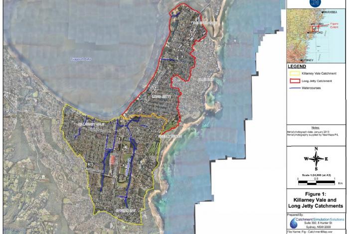
Killarney Vale and Long Jetty Catchments - Floodplain Risk Management Study and Plan
Central Coast Council's Floodplain Risk Management program has identified the Killarney Vale and Long Jetty catchments as prone to overland flooding across the following suburbs:
- Killarney Vale
- Bateau Bay
- Shelly Beach
- Long Jetty
- The Entrance.
A draft of the Killarney Vale and Long Jetty Catchments Floodplain Risk Management Study and Plan was placed on public exhibition for a period of six weeks (25 June - 5 August 2020) for the community to review. This draft study and plan was developed based on a detailed analysis of the feedback we received from our first round of community consultation in 2017, and an assessment of potential management measures.
The study and plan has now been finalised and adopted by Council.
Community members are still able to:
- view the final draft study and plan: Take a look at the final draft of the Killarney Vale and Long Jetty Catchments Floodplain Risk Management Study and Plan online in the document library on the right of this page
- read our frequently asked questions: Make sure you check out our frequently asked questions on our main floodplain planning and management page to see if we haven't already answered your question!
- take a look at the engagement summary: Read about who we reached and what the results were from the public exhibition period
*This website does not necessarily represent the opinions of the NSW Government or the Department of Planning, Industry and Environment.
Document Library
Segmented Documents
Timeline
About the study and plan
The aim of this study and plan was to reduce the impact of flooding and flood liability to residents and business owners living within each catchment area. As part of the NSW Government's Flood Prone Land Policy, consideration is given to social, economic, environmental and flood risk parameters to help evaluate a range of potential flood mitigation measures.
The study was prepared by the specialist flood consultant Catchment Simulation Solutions and was funded by Council with additional funding and technical support provided by the NSW Government’s Department of Planning, Industry and Environment.
About Killarney Vale and Long Jetty catchment
The suburbs within each catchment are densely populated and each catchment is drained by a network of channels, stormwater drains and detention basins. During periods of heavy rainfall, the capacity of the stormwater and creek system can be exceeded, resulting in overland or 'flash' flooding across homes and streets which flows into Tuggerah Lake.
For residents within the catchment who have experienced severe flood events in the past, this causes significant disruption and inconvenience. There is also potential for property damage as well as a risk to life.
Inundation from elevated water levels in Tuggerah Lake is not assessed as part of this study as this flooding mechanism was previously addressed as part of the Tuggerah Lakes Floodplain Risk Management Study and Plan (WMAwater, 2014). This study was only concerned with overland flooding from the local catchments draining into Tuggerah Lake.
Overland flood study findings
An overland flood study for the catchment was prepared in 2014. The flood study determined that partial inundation of up to 1,375 properties is predicted during a 1%AEP flood event out of a total of 7,400 properties located within the study area. The most notable problem areas can be seen in the document titled '1% AEP Depths and Velocities' located in the document library to the right of this screen, and include:
- Properties in the vicinity of, and downstream of Hume Boulevard, Killarney Vale, particularly around Ferndale Street where overland flow paths pass through a number of properties.
- Those properties adjacent to the Lower Saltwater Creek, particularly downstream of Wyong Road and the Entrance Road.
Your questions answered!
Is there a plan to complete curb and guttering in the streets that have received partial kerb and guttering? (i.e. Koorinda Avenue, Long Jetty)
This was not specifically recommended as part of this plan as inundation along Koorinda Avenue does not appear to be as significant as other areas of the catchment.
At this stage, the kerb and guttering is being prioritised across the upper catchment areas where water depths are shallower and the inclusion of kerb and gutter has a more significant impact on containing water to the roadways.
The drains on Cook Road, leading to the hospital, overflow almost every time there is any rain. Then, after the rain has stopped, on the eastern side of road, the open drains don't empty completely. Although this is a short street it has plenty of traffic leading to the hospital. This street would benefit from kerb and gutters as it always floods. Is this part of the plan?
Your observations are consistent with the flood mapping presented in the report. It is noted that kerb and gutter is already installed in the areas most significantly impacted location (i.e. the eastern end of Cook Road) and alternate access through the Health Care Centre site from Wyong Road could be provided if Tasman Ave/Cook Road was cut by water. As a result, it was not considered as a higher priority flooding area.
At this stage, the kerb and guttering is being prioritised across the upper catchment areas where water depths are shallower and the inclusion of kerb and gutter has a more significant impact on containing water to the roadways.

