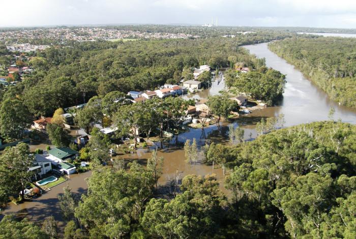
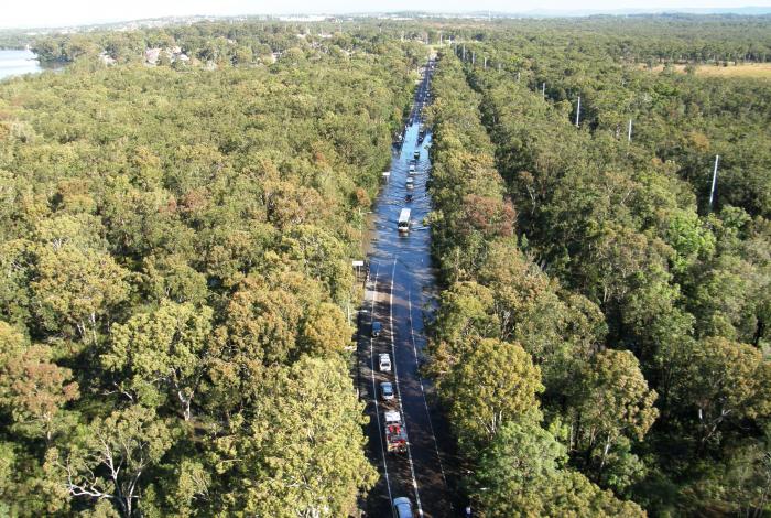
Central Coast Council's Floodplain Risk Management program identified the Wallarah Creek catchment as prone to flooding across the following suburbs:
- Blue Haven
- Wallarah
- Bushells Ridge
- Doyalson
- San Remo
- Charmhaven
- Woongarrah
A draft of the Wallarah Creek Floodplain Risk Management Study and Plan was placed on public exhibition for a period of six weeks (25 June - 5 August 2020) for the community to review. This draft study and plan was developed based on a detailed analysis of the feedback we received from our first round of community consultation in 2017, and an assessment of potential management measures.
This study and plan has now been finalised and adopted by Council.
Community members are still able to:
- view the final draft study and plan: Take a look at the final Wallarah Creek Catchment Floodplain Risk Management Study and Plan in the document library on the right of this page
- read our frequently asked questions: Make sure you check out our frequently asked questions on our main floodplain management page to see if we haven't already answered your question!
- take a look at the engagement summary: Read about who we reached and what the results were from the public exhibition period
*This website does not necessarily represent the opinions of the NSW Government or the Department of Planning, Industry and Environment.
Documents
Segmented Documents
Timeline
About the study and plan
The Wallarah Creek Catchment Flood Study, prepared for Council by Catchment Simulation Solutions in 2016, provides a technical assessment of flood behaviour throughout the catchment and identified that during periods of heavy rainfall there is potential for water to overtop the banks of the various creeks and waterways and inundate adjoining properties. There is also potential for the capacity of the stormwater system to be exceeded leading to local overland flooding.
This project was the next step in the NSW Government’s Floodplain Risk Management Process. Using the information from the preceding flood study, it has evaluated, recommended and prioritised measures for better managing the existing, future and continuing flood risk across the catchment.
The study was prepared by the specialist flood consultant Catchment Simulation Solutions and was funded by Council with additional funding and technical support provided by the NSW Government’s Department of Planning, Industry and Environment (DPIE).
About Wallarah Creek catchment
The Wallarah Creek catchment comprises 33km2 of largely undeveloped land.
This catchment is drained by two major watercourses (Spring Creek and Wallarah Creek) as well as a number of unnamed tributaries which carry runoff in an easterly direction into Budgewoi Lake. A local stormwater system also drains runoff from the urban areas into creek system.
During periods of heavy rainfall, the capacity of the stormwater system can be exceeded, resulting in overland or 'flash' flooding across homes and streets. There is also potential for water to overtop the banks of the creeks and inundate the adjoining floodplain. Flooding has been experienced across the catchment on a number of occasions in the past including in 2007 and more recently in 2020.
Inundation from elevated water levels in Budgewoi Lake was not assessed as part of this study as this flooding mechanism was previously addressed as part of the Tuggerah Lakes Floodplain Risk Management Study and Plan (WMAwater, 2014). This study only concerned flooding from the local catchment draining into Budgewoi Lake.
Your questions answered!
When will the walkway between Allambee Crescent and Colorado Drive be cleaned up? Water sits there, which is unhealthy, and it is also is a rubbish dumping area.
Council understands your concern about the clean-up and rubbish being dumped on the walkway. However, please note that illegal dumping and clean outs are not in the scope of this Floodplain Risk Management Study and Plan (FRMSP) currently on exhibition.
Illegal dumping can be reported to the Hunter-Central Coast Regional Illegal Dumping (RID) Squad on 131 555 or via https://ridonline.epa.nsw.gov.au/#/home.
Alternatively, you can report it to Council by calling our friendly customer service team on 1300 463 954 or through our online customer service portal (link provided below). Lodging this way ensures it is registered in Council's system and will provide you with a reference number of which you'll be able to track if necessary. www.centralcoast.nsw.gov.au/customerportal

